Updated 9 September 2021 at 14:19 IST
MRI 3D images reveal 'spectacular' ice age relics beneath the North Sea
“Although we have known about huge glacial channels in North Sea for some time, this is first time we've imaged fine-scale landforms," scientists at BAS said.
- India News
- 3 min read
In a rare discovery, scientists have unveiled previously hidden ‘spectacular’ ice age landscapes beneath the North Sea using 3D seismic reflection technology, similar to the MRI (magnetic resonance imaging) technology. The images released on 9 September depicted unprecedented details of huge seafloor channels, each about the size 10 times wider than the River Thames. In a press release on Thursday, the British Antarctic Survey announced that its international team of scientists has discovered the previously undetectable landscapes that formed beneath the vast ice sheets stretching across much of the UK and Western Europe, thousands to millions of years ago.
“These ancient structures provide clues to how ice sheets react to a warming climate,” scientists explained.
The findings are published in the journal Geology. The British Antarctic Survey released the MRI image comparing the resolution of the new high-resolution 3D seismic reflection data to previous 3D seismic data from the region. In the recent image, scores of buried channels and their internal structures were demonstrated by the contrast between the two images.
Buried hundreds of meters beneath seafloor
Scientists explained that the tunnel valleys, which were found buried nearly hundreds of meters beneath the seafloor in the North Sea, are remnants of huge rivers that were the ‘plumbing system’ of the ancient ice sheets as they melted in response to rising air temperatures. “The origin of these channels was unresolved for over a century. This discovery will help us better understand the ongoing retreat of present-day glaciers in Antarctica and Greenland,” said the lead author James Kirkham, from the British Antarctic Survey (BAS) and the University of Cambridge.

[New data revolutionises internal structures as demonstrated by the contrast between the left and right of the image. Credit: James Kirkham, BAS]
Advertisement
“In the way that we can leave footprints in the sand, glaciers leave an imprint on the land upon which they flow. Our new cutting edge data gives us important markers of deglaciation,” he stressed.
New research led by @BAS_News @Cambridge_Uni scientist James Kirkham @JD_Kirkham reveals huge ice age #NorthSea seafloor channels in unprecedented detail, giving clues to how ice sheets react to climate warming: https://t.co/uOj4PMh9Sb@BritGeoSurvey @scottpolar pic.twitter.com/Yazk7JyJ0E
— British Antarctic Survey (@BAS_News) September 9, 2021
Meanwhile, a co-author and a geophysicist at BAS, Dr. Kelly Hogan, said: “Although we have known about the huge glacial channels in the North Sea for some time, this is the first time we have imaged fine-scale landforms within them. These delicate features tell us about how water moved through the channels (beneath the ice) and even how ice simply stagnated and melted away.” Furthermore, Hogan informed that it would be an extremely challenging task to detect the large ice sheets in the present age as the moving water and sediment affects the ice flow, which according to BAS, is important control on-ice behaviour.
“Using these ancient channels to understand how ice will respond to changing conditions in a warming climate is extremely relevant and timely,” the agency stated.

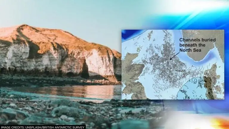
[A map of the North Sea showing the distribution of buried channels or tunnel valleys that have been previously mapped using 3D seismic reflection technology. The limit of the last ice sheet to cover the UK around 21,000 years ago)is overlain. Credit: James Kirkham]
Advertisement
Published By : Zaini Majeed
Published On: 9 September 2021 at 14:19 IST