Updated 10 April 2023 at 11:16 IST
USA: 'Hidden' tornado tracks seen in Arkansas, reveals satellite imagery
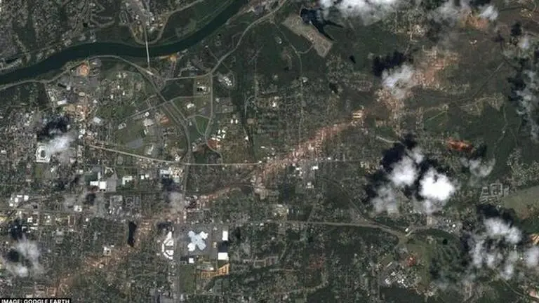
Satellite imagery has revealed a 60-kilometer-long track of moist earth in Arkansas in the United States that was invisible to human eyes.
- Science News
- 4 min read
If a powerful tornado sweeps through a city, it frequently causes extensive damage such as destroyed buildings, shattered tree branches, and scattered debris. However, if a similarly strong storm occurs in a desolate and vegetation-free area, it is considerably more challenging to detect in hindsight.
According to a report published in the Geophysical Research Letters on March 28, a 60-kilometre-long strip of damp soil was uncovered in Arkansas through the use of satellite imagery. This feature was not visible to the naked eye and is believed to have been created by a tornado that removed the top layer of soil.
This technique of searching for "hidden" tornado tracks is especially useful for gaining a better understanding of storms that occur during the winter season when vegetation is sparse, the researchers argue. Recent research has indicated that winter storms are expected to become more severe as the climate continues to warm up, reported Science News.
The news outlet quoted Darrel Kingfield, a meteorologist at the National Oceanic and Atmospheric Administration in Boulder, Colorado, who was not part of the study, noted that more than 1,000 tornadoes hit the United States every year, as reported by the National Weather Service. However, not all of them have an equal chance of being examined.
Advertisement
One reason why some tornadoes receive more scrutiny than others is that storms that travel over populated areas are more likely to be examined, according to Kingfield. He explained that there has been a significant bias towards analysing storms that affect highly populated regions. Additionally, tornadoes that occur over vegetated areas tend to be well studied as they leave clear marks (tornado tracks) on the landscape. Kingfield, who has studied forests that have been damaged by tornadoes, stated that uprooted vegetation and fallen trees serve as markers that reveal the storm's trajectory.
Tornado season in USA
The peak seasons for storms in the United States are typically spring and summer, with more than 70 percent of tornadoes occurring between March and September, according to NOAA. However, on December 10, 2021, a group of storms began rapidly moving across the central and southern regions of the country.
Advertisement
These tornadoes caused over 80 fatalities as they moved through both urban and rural areas, including farmland that had already been harvested for the season.
Jingyu Wang, a physical geographer at Nanyang Technological University in Singapore, and his team aimed to identify the signs of these lethal storms in desolate and unpopulated landscapes.
When even moderately weak winds swirl, they can suck up multiple centimetres of soil. Since deeper soil layers tend to contain more moisture, a tornado should leave behind a distinctive clue: a lengthy strip of soil that is moister than usual. The soil moisture level is linked to two characteristics: its texture and temperature, both of which can affect how much near-infrared light the soil reflects.
To identify these signs, Wang and his team studied near-infrared data gathered by NASA's Terra and Aqua satellites, searching for indications of soil moisture changes that are consistent with the path of a tornado.
Upon examining the data obtained shortly after the 2021 storm outbreak, Wang and his colleagues identified a signal in northeastern Arkansas that was consistent with a 60-kilometre-long track of moist soil. The team concluded that this feature was most likely caused by a powerful storm as tornadoes had been previously reported in that area outside of Osceola.
Kingfield agrees that this approach is reasonable, and findings like these can uncover signs of tornadoes that may have otherwise gone unnoticed. However, he notes that this technique is most effective in areas where soils are capable of retaining moisture. "You need to have clay-rich soils," he said.
Despite this limitation, Kingfield believes that these findings offer potential for studying other tornadoes. It is always beneficial to have a new method for estimating the strength, path, and structure of a storm. However, many storms remain relatively unexamined due to when and where they occur. "Now we have this new ground truth," he noted.
Published By : Digital Desk
Published On: 10 April 2023 at 11:16 IST