Updated 22 March 2025 at 12:17 IST
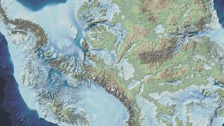
What If Antarctica Had No Ice? Scientists Unveil Mind-Blowing Images of How it Would Look
For years, the BAS has been studying the bedrock beneath Antarctica's thick ice using advanced radar, sound waves, and gravity mapping techniques.
- Science News
- 4 min read

New Delhi: Antarctica, a land now covered by a massive ice sheet, was once a lush and vibrant environment, teeming with prehistoric life. It’s hard to imagine today, but beneath kilometres of thick ice, an ancient landscape remains hidden, one that has never been witnessed by human eyes. However, to give an idea, a team led by glaciologist Hamish Pritchard of the British Antarctic Survey gives crucial information to understand the complexity of the ice land in its paper published in the Scientific Data.
For years, the BAS has been studying the bedrock beneath Antarctica's thick ice using advanced radar, sound waves, and gravity mapping techniques.
These efforts have led to the creation of the most detailed map to date, revealing hidden geological features like mountain ranges, ancient riverbeds, deep basins, and vast plains.
Advertisement

This data is crucial for scientists studying the intricate relationship between land and ice, particularly as Antarctica changes due to a warming climate.
Uncovering the Hidden World Beneath the Ice
A team led by glaciologist Hamish Pritchard, the experts from BAS explains that this new information provides a better understanding of how ice moves across the continent as temperatures rise. "This is the fundamental information that underpins the computer models we use to investigate how the ice will flow across the continent as temperatures rise," Pritchard explains.
Advertisement

He compares Antarctica’s ice flow to syrup poured over a rock cake: "Imagine pouring syrup over a rock cake – all the lumps, all the bumps, will determine where the syrup goes and how fast. And so it is with Antarctica: some ridges will hold up the flowing ice; the hollows and smooth bits are where that ice could accelerate."
The idea of what Antarctica would look like without ice sparks fascinating questions. Thanks to modern technology, we have answers to these questions.
Using planes and satellites equipped with advanced metrology tools, the British Antarctic Survey has spent over six decades gradually adding more data to build a comprehensive map of what lies beneath the ice.
Bedmap3: The Latest Detailed Map
The latest iteration of this effort, known as Bedmap3, is the most detailed map yet. It combines data from planes, satellites, ships, and even dog sledge teams on the ground, contributing a staggering 82 million data points. These additions fill in crucial gaps from previous surveys, revealing even more about Antarctica’s hidden landscape.
One such gap was the location of the thickest ice sheet, previously thought to be in the Astrolabe Basin in Adélie Land.
Bedmap3 provides clarity, especially in regions near mountains, coastlines, and nunataks (isolated peaks protruding through the ice). It has improved our understanding of areas surrounding the South Pole, the Antarctic Peninsula, and the Transantarctic Mountains.

Shedding Light on Ice Thickness and Volume
With these new insights, scientists can now more accurately calculate the volume of ice covering the continent. Antarctica’s ice is estimated to have a total volume of 27.17 million cubic kilometres and covers an area of 13.63 million square kilometres.
The mean thickness of the ice, including the ice shelves, is 1,948 meters, and excluding the shelves, it’s 2,148 meters.
If all the ice were to melt, it would contribute to a 58-meter rise in sea levels, a figure consistent with previous estimates, but with some important nuances.
Peter Fretwell, a cartographer with the British Antarctic Survey, explains, "In general, it's become clear the Antarctic Ice Sheet is thicker than we originally realised and has a larger volume of ice that is grounded on a rock bed sitting below sea-level."
"This puts the ice at greater risk of melting due to the incursion of warm ocean water that's occurring at the fringes of the continent. What Bedmap3 is showing us is that we have got a slightly more vulnerable Antarctica than we previously thought," he added.
While there might be many possibilities this discovery marks a significant step in our understanding of Antarctica’s geography and its role in Earth's changing climate.
Published By : Tanisha Rajput
Published On: 22 March 2025 at 12:17 IST
