Updated 2 December 2021 at 16:12 IST
Scientists analyse La Palma volcanic eruption
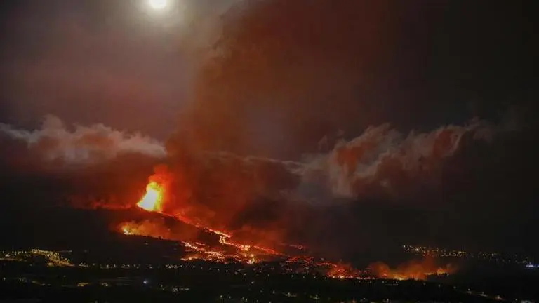
The eruption of the Cumbre Vieja volcano on the La Palma island, which lies on the western end of the Canary Islands archipelago, in the Atlantic Ocean, began on September 19.
- World News
- 3 min read
The eruption of the Cumbre Vieja volcano on the La Palma island, which lies on the western end of the Canary Islands archipelago, in the Atlantic Ocean, began on September 19.
In the 10 weeks since then, at least 11 different lava flows have been identified by scientists, covering at least 1,100 hectares (2,700 acres) of land, including thousands of homes, roads, power lines and irrigation pipes for the economically important banana plantations of the island.
The scientists have come with eagle-eyed drones and high-precision spectrometers.
Aided by satellites, they analyze gas emissions and the extent and direction of molten rock flows.
Advertisement
And, on the ground, they collect everything from nanoparticles to 'lava bombs' the size of watermelons that one of nature's most powerful forces hurl as incandescent projectiles.
The dangerous and delicate task of retrieving samples of the incandescent lava rocks is sometimes left to the members of Spain's Military Emergency Unit.
Advertisement
They prepare for their mission donning gas masks and helmets.
Wearing protective gloves, boots and clothes they take great risks, getting dangerously close to an unstable, active lava flow.
Scientists from around the world flocking to La Palma, an eastern Atlantic Ocean island, are using an array of new cutting-edge technologies available to them in 2021 to scrutinize a rare volcanic eruption from land, sea, air — and even from space.
The last eruption, one decade ago on the southern island of El Hierro, happened just off the coast, which made it more difficult for volcanologists trying to collect samples.
The previous land volcano erupted in La Palma, in 1971, the year when Valentin Troll, a petrology expert with Sweden's Uppsala University and co-author of a geology study of the archipelago, was born.
"It's been an exciting experience, it's been mind blowing literally to see many of these processes in action," he said.
The ultimate goal is to use a unique window of opportunity to understand better volcanic eruptions: how they form, develop and, even more crucially for the islanders in this Spanish archipelago, how and when they end.
But despite recent technological and scientific leaps, they can only do a lot of guessing of what happens in the largely unknown underworld where magma is formed and melts any human-made piece of equipment.
The deepest that humans have been able to drill through the planet's crust has been just over 12 kilometers (40,000 feet, 7.6 miles), a feat that soviet scientists achieved in 1989.
"We are probably beginning to know more about the stars than about what happens under our feet," Pedro Hernandez, a Canary born volcanic who works for the Canary Island Volcanology Institute (Involcan), said.
"It is very difficult to know, with exact scientific accuracy, exactly what is happening at 40 or 80 kilometres deep."
Despite its limited resources, Involcan has been producing daily reports that inform civil protection authorities as they decide whether to evacuate or issue lockdowns when gas concentrations become too toxic for residents.
That means analyzing terabytes of data, both from automatic detectors in strategic locations and from samples recovered in field trips.
IMAGE: AP
Published By : Associated Press Television News
Published On: 2 December 2021 at 16:12 IST