Updated 22 March 2023 at 11:37 IST
Afghanistan Earthquake felt across North India: All about the Indian plate’s tectonics
As an earthquake of magnitude 6.6 struck Afghanistan on Tuesday night, it rocked several parts of Delhi-NCR, Punjab, Haryana and other parts of North India.
- India News
- 3 min read

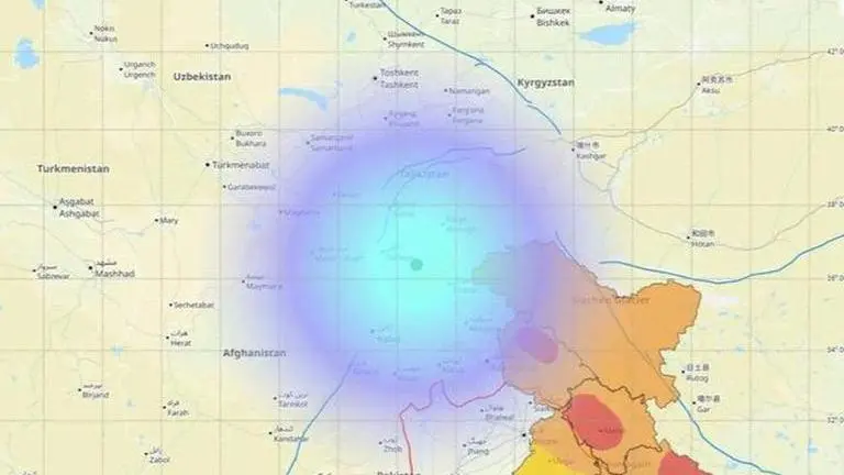
Massive tremors lasting for several seconds were felt in Delhi and other parts of North India as a strong 6.6-magnitude earthquake struck Afghanistan on Tuesday night, the US Geological Survey (USGS) said.
According to the US Geological Survey (USGS), the earthquake was deep, with its origin 187.6 km below the earth’s surface. Notably, deep earthquakes tend to be felt over large distances, which is why tremors were experienced in several areas of North India including Punjab, Haryana, Ghaziabad, Delhi-NCR, Rajasthan’s Jaipur, and Jammu and Kashmir.
Reports by the US Geological Survey (USGS) said, "The earthquake's epicentre was close to Jurm in northeastern Afghanistan, about 300 km north of Kabul and not far from Afghanistan's borders with Tajikistan."
Since they have more energy when they emerge on the surface, shallow earthquakes are generally more devastating. Deeper earthquakes have lost a lot of their energy by the time they reach the surface. Even though they lose energy while travelling further distances, deeper earthquakes produce less damage because the seismic waves travel farther and flow radially upward to the surface.
Advertisement
The Indian plate’s tectonics
The Indian Plate, also referred to as the India Plate, is a small tectonic plate that crosses the equator in the Eastern Hemisphere. India, which originally belonged to the ancient continent Gondwana, split apart from the rest of it (Gondwana) 100 million years ago and started to drift to the North. The majority of South Asia, or the Indian subcontinent, is covered by the Indian Plate, as is a segment of the basin of the Indian Ocean, which includes parts of South China and western Indonesia, as well as Ladakh, Kohistan, and Balochistan.
Movement of Indian Tectonic plate
The Indian tectonic plate includes Peninsular India and the Australian continental portions. The Himalayan subduction zone creates the northern plate boundary in the form of continent-continent convergence. The Indian plate extends through the Arakan mountains, also called Rakhine Yoma, in the east in Myanmar. The Western margin follows the Kirthar Mountain of Pakistan which extends along the Makrana coast (Pakistan and Iranian coasts) and joins the spreading site from the Red Sea rift (Red Sea rift is formed due to the divergence of Somali plate and Arabian plate) south-eastward along the Chagos Archipelago (Formed due to hotspot volcanism).
Advertisement
The boundary between India and the Antarctic plate is also marked by an oceanic ridge (divergent boundary) running in roughly W-E direction and merging into the spreading site, a little south of New Zealand.
About 40-50 million years ago, India collided with Asia causing uplift of the Himalayas as the Indian plate and the Eurasian plate were close to the equator back then. Notably, the northward movement of the Indian tectonic plate pushing slowly against the Asiatic plate is visibly evident by the frequent earthquakes in the region.
What leads to an earthquake?
As the earth's crust is made up of large tectonic plates which float on top of the Earth's molten mantle, these plates steadily move slowly and constantly, either away from each other or towards each other or past each other, in a process called plate tectonics.
When two tectonic plates move against each other, they are stuck, thus building up pressure as they continue to push against each other. Eventually, this pressure causes the rocks to deform and eventually break which as a result releases energy in the form of seismic waves. These waves travel through the Earth's crust and cause the ground to shake, resulting in an earthquake.
Published By : Megha Rawat
Published On: 22 March 2023 at 11:37 IST
