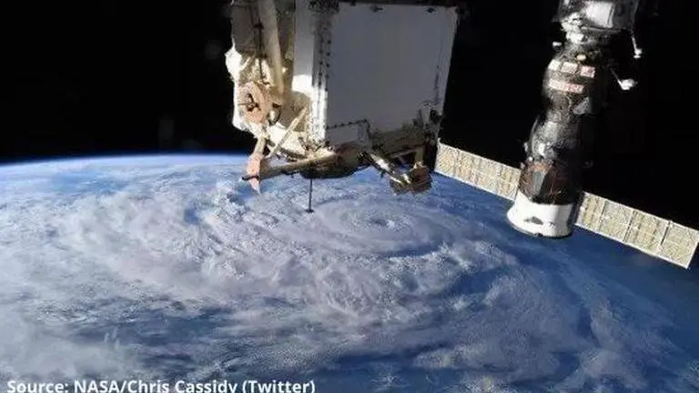
NASA Astronaut snaps breathtaking pictures of Hurricane Genevieve from ISS, see here
NASA Astronaut Chris Cassidy recently captured some stunning images of the Hurrican Genevieve approaching California. See the images of the tropical storm.
- Science News
- 3 min read

NASA astronauts and satellites have been monitoring Hurricane Genevieve for some time now. The formerly Category 4 storm moved rapidly towards California after passing through Mexico's Baja coast Thursday, Aug. 20. However, NASA astronaut Chris Cassidy sent three pictures of the tropical storm on Wednesday, Aug. 19 from the International Space Station. The images show the eye and the overall size of Hurricane Genevieve. Read on to know more.
Source: NASA/Astronaut Chris Cassidy
Hurricane Genevieve pictures from International Space station
The images of the tropical storm were captured beneath the robotic Canadarm2, which is the station's solar panels and a Soyuz spacecraft. In addition to this, the GOES-16 satellite also obtained a dramatic video of Hurricane Genevieve on Wednesday. The picture was tweeted by the National Oceanic and Atmospheric Administration on its official Twitter handle. The tweet also revealed that the sustained wind speeds reached a maximum of 115 mph which is 185 km/h.
Source: NASA/Astronaut Chris Cassidy
For our #ImageOfTheDay, @NOAA's #GOESEast used its hi-res visible band to view #HurricaneGenevieve's eye. As of Wednesday p.m., #Genevieve had a maximum sustained wind speed of 115 miles per hour. More: https://t.co/vCPKN24LBq pic.twitter.com/hUCYSGv0i0
— NOAA Satellites (@NOAASatellites) August 19, 2020
Advertisement
NASA has revealed in a statement that NOAA’s Suomi NPP satellite has also been monitoring Hurricane Genevieve’s progress. The satellite has been observing the Hurricane in infrared wavelengths to give more information about the storm's strength, structure and size. NASA shared a nighttime image of Genevieve based on data from Suomi's Visible Infrared Imaging Radiometer Suite (VIIRS) instrument. Describing the image, NASA revealed that the tropical storm’s eye was still visible and well defined. The space agency also confirmed that it was surrounded by powerful thunderstorms.
Source: NASA
Advertisement
Has Hurricane Genevieve weakened?
According to a NASA report, Hurricane Genevieve has now weakened to a tropical storm. However, it still has the potential of inflicting substantial damage. Continued heavy rainfall from Genevieve can lead to life-threatening flash flooding and mudslides in the far southern areas of California.
NASA Astronaut captures breathtaking pictures of Earth from Space
We think Earth looks beautiful from every angle. @NASA_Astronauts capture some of the most stunning pictures 📸 of our home planet. For #NationalPhotographyDay, enjoy the view from space with @AstroDrewMorgan. https://t.co/9ud9ZkZv5h pic.twitter.com/FFMJtYOGmL
— NASA Earth (@NASAEarth) August 19, 2020
On August 20, NASA shared a video of astronaut Andrew Morgan clicking stunning pictures of Earth from the International Space Station. The astronaut is seen using a wide-angle lens camera. The astronaut revealed that the ISS was flying North East and had just crossed the Red Sea in Saudi Arabia.
While clicking the stunning images of Earth from ISS, the astronaut is seen describing several locations on Earth that are visible from ISS. One of these locations in the Sinai Peninsula of Egypt. The full length of the Nile River was is also visible in the video. The ISS is seen moving towards Middle East Africa. As the video progressed viewers can see the Caspian Sea as well.


